
Ground-penetrating radar (GPR) serves as a critical tool in locating and identifying underground conduits, playing an essential role in various applications. Its significance lies in its capability to non-invasively and detect subsurface structures. GPR uses electromagnetic radiation to penetrate the ground, sending signals that bounce back upon encountering different materials, allowing for the creation of detailed underground images. This technology aids in preventing accidental damage to buried infrastructure during excavation or construction facilitating efficient planning and development. Its ability to provide real-time data and precise mapping of subsurface structures makes GPR an invaluable asset in investigating existing conduits and executing new projects with enhanced precision.
The utilization of GPR holds immense significance in the preservation and exploration of the stone spouts within Kathmandu Valley. Elements of these ancient water sources, crucial elements of Nepal's cultural heritage, are hidden beneath the ground. The source and drainage are beneath the surface. GPR technology plays a pivotal role in locating and mapping these ancient structures, employing electromagnetic waves to penetrate the earth and generate detailed subsurface images. By effectively revealing the precise path locations, GPR aids in the conservation and restoration efforts, preventing inadvertent damage during excavation and construction. Its non-invasive nature ensures the preservation of these culturally significant structures, contributing to the safeguarding of Nepal's heritage and enabling informed decisions for their maintenance and restoration.
Each type of GPR possesses unique strengths, catering to specific needs in fields like archaeology, geophysics, hydrological studies, contributing significantly to non-destructive subsurface investigations and accurate imaging.
In GPR, there exists an inverse relationship between the frequency of the radar waves used and the depth at which the radar can effectively penetrate.
Generally, higher frequency radar waves, such as those in the hundreds of megahertz (MHz) range, can provide high-resolution images but tend to penetrate shallow depths. These frequencies are more suitable for imaging objects closer to the surface, typically within the range of a few meters deep.
On the other hand, lower frequency radar waves, typically ranging from tens to a few hundred megahertz, have the capability to penetrate greater depths.
So, while higher frequencies offer better resolution but shallower depth penetration, lower frequencies provide deeper penetration but might sacrifice some resolution. The selection of frequency in GPR applications depends on the specific depth range required for the investigation or survey. Adjusting the frequency used in GPR systems allows for optimization based on the depth of the target objects or structures being examined.
Ground-penetrating radar (GPR) technology encompasses various types, each with distinct capabilities tailored for specific applications.
Time-domain GPR is highly versatile, utilizing short-duration radar pulses to detect objects at various depths.
Frequency-domain GPR operates by transmitting signals at different frequencies, offering enhanced resolution for shallow subsurface imaging, beneficial in archaeological and geo-hydrological applicaitons.
Stepped-frequency GPR, with its continuous frequency variations, offers a balance between depth penetration and resolution, suitable for diverse geological and engineering projects.
Multi-channel GPR systems use multiple antennas for simultaneous data collection, facilitating faster scanning and improved data accuracy for large-scale surveys.
3D GPR systems provide detailed three-dimensional mapping of subsurface structures, enabling precise visualization for construction planning and infrastructure assessment.
Limitation of GPR
But conditions vary from site to site, from area to area within the same site, and location to location within the same area. It's difficult to be certain how deep you can see with GPR without trying it at the survey location.
Therefore penetration and data collection vary very much from the environment (sub-surface environment).
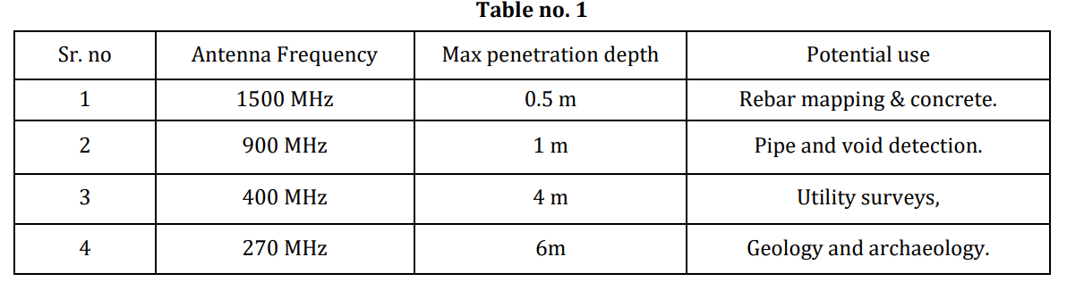
As per USRadar Inc claim ( How Deep Does GPR Go? 3 Factors to Consider - US Radar: Leading GPR Systems Innovators & Providers ), following are the depth data.

(Patil et al., 2021, #) gives penetration depth as following:
It is the general intention to use higher frequencies as they provide higher resolution. But for the depth lower frequencies need to be considered. Thus combination of multiple frequencies is required.
As per (Rhee et al., 2021, #) The combination of the plan view by depth and cross- and longitudinal sections of the GPR data achieved from the 3D GPR such as the multichannel GPR, makes analysis easier and more accurate.
Study by CCO in the report (Chiva Chaitya Organization, 2023, # Unpublished) concludes that Hiti System rely on swallow aquifer. The static water level of shallow aquifer varies from 2 to 16 meters. An aquifer thickness map indicates that most stone spouts tap into aquifers within thicknesses ranging from 2 to 6 meters.
It concludes that a thorough systematic study of each stone spout is necessary before revival. This study should include tracking its conduits and source area (aquifer).
Thus for long term work on Hitis a multifrequency/multi channel 3D GPR is a mandatory tool, for the purpose for informed and scientific decision making in the field of Hiti System. The application will be for both conduits as well as the subsurface water detection.


Comments
Post a Comment